NEW Story: Sunday Morning
A Comprehensive Map of the World’s Last Great Utopia, Vekllei

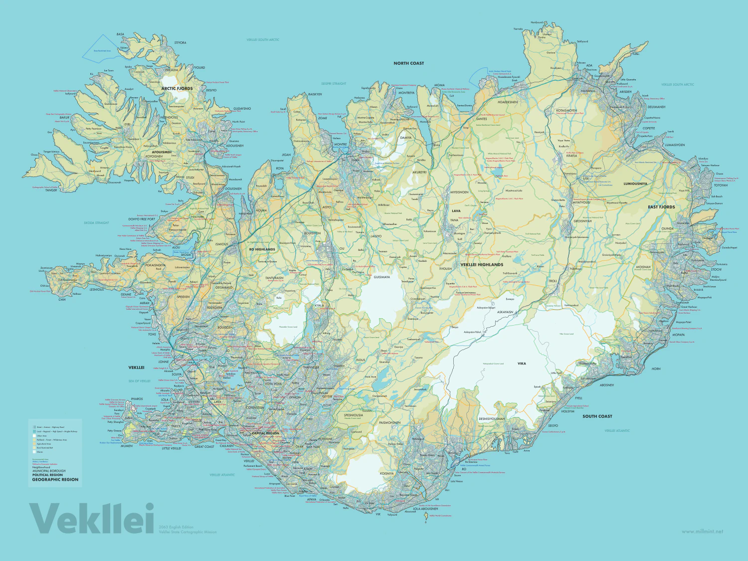
Vekllei is the last great utopia of the world, defying attempts to predict the curve of progress and standing alone in its radical embrace of moneylessness and the goodness of people. This is what it looks like; here are its streets; its cities and villages.
A map lays a framework to conceptualise what the lives of these people might look like. You can seperate nature from the city, and places from the paths. You can see where they choose to visit and live, and where lie fresh springs and cool stone lava fields so remote you might never see them.
It is easy to forget that Vekllei insists it is a city state – that the Home Island, pictured in this map, is a single continuous neighbourhood. There is visible urban settlement across the entire southwest to northeast, which are home to the majority of Vekllei’s 22 million people. Elsewhere, the description is stretched thin, with large swathes of forest and wilderness separating boroughs. Vekllei is divided into 100 boroughs of varying size and population, demarcated by gold borders here, further undermining Vekllei’s “continuous city.”
This is Version 1 of an evolving Vekllei map, complete with strategic features and road network down to the branching street level. We see here the “main thoroughfare” of the transport system, meaning regular timetabled commuter lines for rail traffic and streets of connection (like alleys, dead-ends and cul-de-sacs). Not depicted is Vekllei’s extensive subway, tram and trolley bus network, among other methods of transport not explicitly shown. This is “Version 1” because it’s incomplete – there are many more features to include, which will be available as the map is updated at millmint.net.
“Vekllei” is about space and our place in it. Much of Upen, Vekllei’s religious animism, is concerned with raw physicality and the deconstruction of human conceptualisations of it. To this end, there are only two types of spaces in Vekllei: the human and the non-human – true wilderness. The farm is an extension of the city, and rural living in Vekllei is no closer to its ambition of “eliminating the industrial burden” than the tangled concrete jungle found in the Great Coast. Hayao Miyazaki described as much in a theatre programme in 1997:
The biggest reason why mountain animals decreased so much is agriculture. It’s human arrogance to say that the country scenery is beautiful. A farm basically takes away the chance to grow from other plants. It’s more like barren land. The productivity of wasteland is higher than that of farmland. It’s the same for other creatures. It’s because of the time (we live in today) is such that I have to even think such things.
Vekllei sharply divides its human and empty land, which it calls “Vekllei” and “nature” respectively. Nature cannot be owned by Vekllei; Vekllei is a human construction. As such, wilderness is sovereign and untouchable, and Vekllei people continue to be afraid of nature. Areas on this map marked “Crown Land” depict nature, with no permanent human settlement permitted – although thoroughfare is occasionally granted for road and rail.
Although there are many immediate conclusions available to the viewer here, they are better expressed towards a finished product. For now, please enjoy the product of dozens of hours of hand-wrought cartography, and look forward to future iterations with more detail and features. If you have suggestions as to features to include, or notice errors on the map, let me know in the comments below.